2025 Utah Trip

Robyn and I enjoy traveling on occasion, and this year we picked the amazing national parks in the southern part of Utah as our playground. Specifically Zion, Bryce Canyon, and Capitol Reef. We’ve done a decent amount of traveling into New Mexico and Arizona but this is our first trip to Utah and it did not disappoint.
We broke the trip into thirds with the majority of our time in Springdale UT (Zion), then Tropic UT (Bryce Canyon), and finally a few days in Torrey UT (Capitol Reef). We elected to make it a point to point flying into Vegas and heading back from Salt Lake City but I suspect coming into SLC and heading south would have been equally fine. The drive from Vegas did allow us a drive through the Virgin River Gorge just south of St George UT on route 15. A nice taste of rock formations we’d soon see in Zion.
Zion National Park…

We stayed just outside Zion National Park entrance at a hotel along the Virgin River. It proved an almost perfect location as we were close enough to walk into the park and either jump on the parks bus system or go straight to the handful of hikes starting at the entrance. Highly recommend finding something close by as it will save a ton of time as you jump into the park for activities.
Day one and the first of three hikes started with the Watchman trail that starts directly to the west of the park entrance. It offered a wonderful first introduction to the park system and a nice stretch of the legs after the day of traveling. The ~700 feet of elevation provided some great first views of Bridge Mountain, Watchman mountain, and the Springdale UT valley. To our surprise there was a helpful Park Ranger at the top of the hike answering everyone’s questions.
Day two gave us a chance for a bit of a day trip over to Page, AZ to see Antelope Canyon and the famous slot canyons. While I’ve seen this space photographed a billon ways, it was nice to chase the light a bit in the space and I think I have a few I rather enjoy for my own collection. Our guide from Adventurous Antelope Canyon Tours was very helpful in providing information about flash floods, how the ground raises/lowers often as sand is washed out by rain and eventually re-deposited by wind, and where most of the famous photos had been taken. We also jumped over to Horseshoe Bend to see the Colorado River wind itself through the Marble Canyon. While the 2+ hour drive to Page was a bit long we both felt it was worth the time and thankful we took the time even though we had plenty to do in Zion. Be mindful of the time change heading back into AZ. Best to use Phoenix as your official time as cell phone time zone indication will flip back and forth based on available connections rather than geolocation.
Day three we connected up with Michael from Cedar and Sage Trekking to help us with a hike up the Narrows and Virgin River. This was by far the toughest of hikes on our trip. Roughly 6 miles total with 2 miles going upriver on some rather rocky terrain. The effort was well worth it as each bend of the river gave way to 1000 foot cliffs carved over millions of years by the very river we were trodding through. Very impressive! We would HIGHLY suggest a local guide for this hike. Michael knew every inch of that river and based on the struggles we observed other hikers experiencing, it was much safer, easier (and informative!) with Michael’s help. Highly recommend Cedar and Sage Trekking!
Day four in Zion with Michael’s help we headed to the Grotto trailhead and the Upper Emerald hike to see the upper and lower Emerald pools. This hike was a wonderful pairing with the more rigorous Narrows hike the day before but it was lovely quick ascent into the valley between Lady Mountain, Mount Majestic, and Castle Dome and a wonderful view of Red Arch Mountain, The Great White Throne, and Mountain of the Sun. The view of the water fall into the upper pool is absolutely breathtaking and we caught the area just as the sun started to reflect off Lady Mountain giving the entire space a complexity different feel. The lower pool and water fall were equally amazing and the hike was well worth the effort. We had some time to kill and jumped into the Museum on the way back offering a great topographic map that we all reviewed our last four days adventures.
We could easily have stayed 10 more days and enjoyed Zion but onward to Bryce Canyon!
Bryce Canyon National Park…
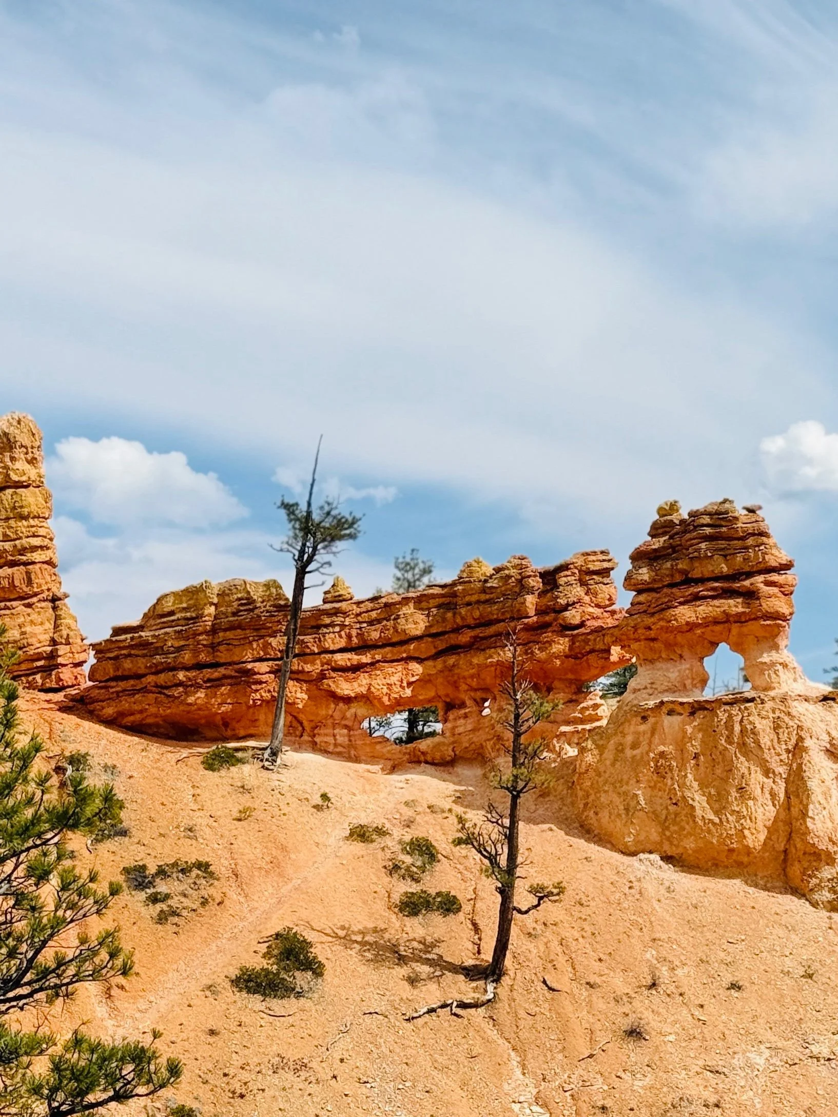
The drive over to Tropic was pretty easy and we could already see a huge change in the vibrant rock formations around the Bryce Canyon area on the drive in.
Our first outing in the area was a short Mossy Cave Trail hike just north of Tropic giving a much closer look of the hoodoos and local tree and plant life. Given the busy schedule in Zion we welcomed a shorter and early day. Robyn and I both noticed the effects of “thin air” at higher elevation - even a short hike left us breathless.
We made up for it on day two with a departure up the Tropic trail which gave us access to both the Navajo trail and Queen’s Garden Trail. While the Narrows in Zion might have been the most difficult, this equally challenging 7+ mile and 1200’ of ascent from base to the rim of Bryce Canyon was a spectacular path to see the park unfold from a wooded path to steep switchbacks as we got closer to the rim. We elected to take the more steep approach up the northern side of the Navajo trail and the ascent was well worth it as the view at the top was like nothing I’ve seen. The decent down the more gradually sloping Queen’s Garden trail was almost perfect and the continued drop down the Tropic gave us one more chance to visit with the Ponderosa Pine trees. The park and trails were busy but nowhere near as packed as the Zion trails during high peak times. Perhaps a consideration when picking out parks in Utah.
We didn’t get a chance to complete Peekaboo Loop Trail but you should consider it if your departure is from the rim and main park area.
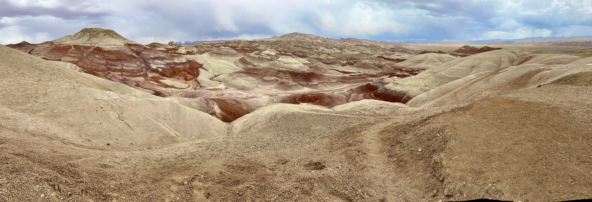
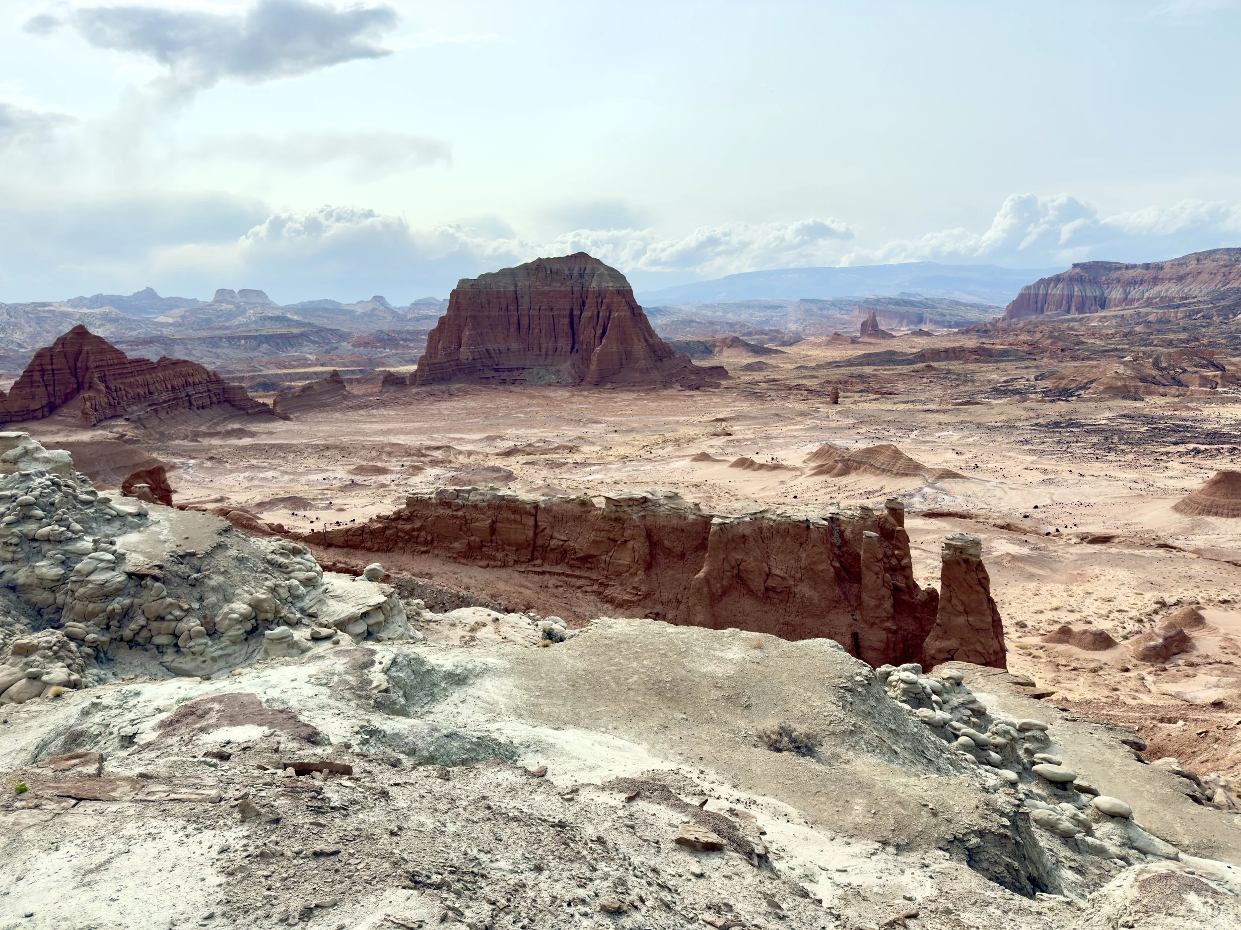
Capitol Reef National Park…

I’ve driven most of the US including the entire CA Route 1 coastline and I’ve always held that area as the gold standard until this trip. The 112 mile trip along Route 12 from Tropic UT to Torrey is now my favorite drive in the US. It in itself is destination and I highly suggest taking this route if you are traveling in the area. Towns like Escalante and Boulder offer some nice pit stops and if you wanted to make a day of it, the Calf Creek Falls trail looks like an amazing hike just south of Boulder.
Given our time remaining, our Capitol Reef excursions were a bit lighter than previous areas of UT. We wanted to see the Bentonite Hills and Cathedral Valley which requires a 4x4 to cross a few larger streams, and more advanced passages so we connected up with Mel from Meridian Tours. Mel was great and even shared a spot that had the largest petrified dinosaur bones I’ve ever seen in situ.
With three parks under our belt this week I can confidently say Capitol Reef is unique in comparison to the other two. The park just feels like it’s actively moving under and around you while you walk among the cliffs. The rocks that have separated and fallen almost feel like it JUST happened, giving the impression of the Earth shedding its outer “skin” like a desert snake around you. Not something I felt at the other parks during this trip, or any other. A quick stop at the Gifford Homestead, Fruita valley, and the Fruita Schoolhouse provided some interesting insight how life in the late 1800’s and early 1900’s.
Wrapping Things Up…
While our trips often start with a simple goal to escape from the responsibilities of life, they almost always take on a much deeper meaning by the end. With the uncertainty of the world’s events, visiting these three parks has provided me with a lovely reminder that the world IS continuing to move forward. Either by the Virgin River in Zion, the winds of Bryce, or the gravity at Capital Reef, change is consistent, and constant! It just requires a wider prospective to really see the beauty of the unrelenting process. Perhaps a nice thought heading into the rest of 2025.
Thanks for reading and I’ve added a few more thoughts below on some resources we found helpful. Hopefully the post is helpful to those heading this direction for some travel!


Tips & Tools of the trip…
Life has been extremely busy so we elected to use a travel agent / advisor to help find some of the locations, hotels, guides, and overall plan. Cali Johnson from Choose Your Own Adventure Travel did a fantastic job finding spaces that fit us like a glove. Highly recommend her and while a travel agent might not be necessary for every trip, it’s nice to know we have some options if needed.
Apple’s updated hike options in Apple Maps was a heavily used feature during the entire trip. Paired with the Maps for MacOS, you can create custom routes by adding trails together which was super helpful. The added plus was the Apple Watch integration which gave little “taps” to the wrist when we were approaching a turn. A quick glance to the watch’s map gave a nice reassurance we were on the correct path and allowed me to focus on the surroundings and beauty of the space around us.
I always struggle deciding how much camera gear to bring. While I did bring the smaller Sony a7c II, 95% of the photos I took on this trip are from the iPhone 16 Pro. For me, I just find the process of hauling cameras counter to taking a vacation so the iPhone is a nice blend of features, quality, and compactness. I think what struck me the most this trip was the improved portrait feature for the camera app. It has struggled with poor edge definitions in the past but updates have improved to the point where it’s the most common photo mode I use. The ultra wide angle was also extremely useful and I was thankful not to have to carry another lens to get it. Having a camera that can capture both 4k and 8k video is pretty amazing. The Cinematic video mode is incredible as it allows post edit focus adjustments. Pairing these options with the built-in iMovie app is crazy useful. I was thankful I had the a7c during the Antelope Canyon tour as the iPhone camera continues to struggle in odd lighting situations but this was the only space I felt required the mirrorless body. As for lens, the 24mm 1.4f was the only thing I mounted, but I also had the 85mm 1.8f just in case I wanted to get something a bit closer.
The National Parks Service app is really great and you should download it prior to jumping into these or any other national park.
You should also consider the annual America the Beautiful—the National Parks and Federal Recreational Lands Pass. We used it in all three parks for this trip and have used it a number of times in the past as well. Great way to support the NPS!